Thursday, May 12, 2011

The rain continues

I wasn't expecting much as far as good weather goes today.  On the way to work at around 6AM there was some dense fog cover.  Visibility wasn't great either.  Currently the temp is 65 degrees with some heavy humidity in the air that can definitely be felt.  The wind is slow but straight from the East at 4 MPH.  There is also 100% cloud cover with a thick layer of stratus clouds. This storm system is moving very slowly through the midwest!
US: Water Vapor Satellite
Above is the water vapor satelite and it can easily be seen that there is a mid latitude cyclone in the center of the country which is the culprit of our stormy slow weather.  This rainy weather should unfortunately continue through the weekend!

Wednesday, May 11, 2011

May Storms!

After a gorgeous day yesterday I knew there was some stormy weather in sight.  As the day progressed it went from humid to cool which meant that the front was coming through.  Early this morning it hit with full force complete with thunder and lightning as well as plenty of rain.  It's good to see the trees and grass greening up!! Today's weather is 68 F with 78% humidity which explains the stormy weather we have seen all day.  currently there are some cumulonimbus / stratus clouds covering the sky.  The wind is from the NNE at about 6 mph so we have a slower moving storm system on our hands. 

US: Current Weather
This surface map shows that we have our Low pressure stationary front taking its sweet time moving through the area.  We can expect this rainy weather to stick around for awhile!

Tuesday, May 10, 2011

May 8ths crazy morning storm

I work early mornings at macys. The first picture is facing east and you can easily see the wall cloud.  The second is facing west. I had just missed a lightning strike. What a difference on each side of the building!


spring has finally arrived... a month late

Finally we have that goreous weather we have been waiting for!  The temperature is currently 76 degrees and SUNNY with a few higher altitude stratus and cirrus clouds.  However, the wind is from the ESE at around 14MPH which means that there is most likely some precipitation headed our way. 
US: Water Vapor Satellite

As can be seen on this water vapor map there is quite a bit of precipitation to our south that is currently being pushed in our direction by the Low that is to our west.
US: Current Weather
  We can anticipate some rainfall within the next few days....so instead of April showers bring may flowers.... apparently its May showers bring June flowers!

Tuesday, April 19, 2011

so much for that huge winter weather?

right now the temperature is hanging right around 40 degrees with some gusting wind at about 20 mph.  The sky is overcast.  As of now we are no longer in a weather warning but a weather alert.  Looking at the surface map it seems taht the weather system is hitting regions to our south and we are catching the top parts which is mainly going to be light snow/rain mix.  As happy as I am that we are not getting 6-10 inches, I am kind of sad that I won't be needing my 4 wheel drive one last time. 
US: Water Vapor Satellite
This map shows the water vapor around the area, with the green being the highest amount of water vapor in the clouds which means varying amounts of precipitation.

Monday, April 18, 2011

colorado low!

Today is quite a bit nicer than it has been for the past few days... however the warmer weather will be short lived.  OF COURSE there will be a huge dumping of snow in our area this week!  I mean its only the middle of April... not a big deal.  The wind is from the Northeast which means there is a storm system on the way. 

US: Current Weather
as can be seen on the map above there is a stationary front going through the middle of the states with a low pressure system into tonight and tomorrow morning we can expect that this low pressure system will be pushing the front to our area.  Hope everyone didn't put their boots and shovels away yet!

Thursday, April 14, 2011

winds from the East... Shits about to go down! Ha! All kidding aside strong winds from the East North East means that a weather system is approaching, along with our falling temperatures and full stratus cloud cover we can expect some weather within 15-20 hours.  US: Current Weather
This current surface weather map shows the jet stream dipping down into a trough bringing along some of that colder arctic air that we are feeling there is also a low pressure system to our south brewing up a weather system.  we can expect precipitation as early as this evening and during the day tomorrow.. maybe it was a little to early to put away the warm clothes!!

Thursday, April 7, 2011

Spring!

todays weather was one of the better days of the week!  The wind has shifted from the NW to the SE which means that there will be some stormy weather and or precipitation in our future.  The highs today were right around 56 degrees and will continue to stay around that range. 

US: Current Weather

as can be seen by the surface map there is a low pressure from moving the bad weather to the northeast.

Tuesday, March 29, 2011

beautiful!

The weather has been quite nice the  past couple days!  As of right now there are clear skies with barely any wind and a temperature of about 32 degrees.  Weather.com says that the wind is from SSW at 1 MPH.  Since the wind is from this direction I can assume that there will be some type of weather system in our near future.
 US: Current Weather
The current surface map shows that there is a smaller system to our south, I believe it will build and move into our area.  there is also a stationary front in the middle of the country becuase of the mountain range.

Monday, March 14, 2011

Today's weather is gorgeous! Finally that spring weather is making its appearance!  Currently in Eau Claire is a very comfortable 40 degrees with zero cloud coverage!  The wind is out of the SW at about 8 mph which means we can expect to see some sort of system rollling through our area, however the warm weather should be staying around for awhile!

US: Current Weather

That southwest wind is pushing the low pressure system to the north and it looks like we will be having some precipitation tomorrow.  RAIN! not snow :)

Tuesday, March 1, 2011

March 1st!

I've always heard that March comes in like a lion and out like a lamb... doesn't seem to be the case today! Right now the temperature is right around 32 degree with winds from the SW around 13 mph.  There is some cloud cover.. but I wouldn't say overcast by any means, a few stray cirrus clouds here and there. 

US: Current Weather

with all of these high pressure systems around the country there are few areas that are having weather issues today! It does look like we have a small system moving in to our NW with the low pressure system bringing it down from Canada! Hopefully it doesn't get too cold this week!

Monday, February 28, 2011

Feb. 28th

The weather today was pretty comfortable! The temperature is a cool 23 degrees and is mostly sunny. with the wind coming slowly out of the WSW at around 7 miles an hour which is bringing down that 'feels like temp' a little bit... Todays current surface map shows......
 US: Current Weather
As you can see we have relatively no cloud cover today.  The high pressure system is pushing that storm off to the east.  however on the west coast it looks like there is a smaller system coming down from the north, the isobars are also showing how the jet stream is starting to dip down over in that area.  Looks like we might be expecting some cooler weather in the future!

Wednesday, February 16, 2011

heatwave!!

the current temp for today is 46 degrees.  46!! I love it.. I've been driving around all day with my sunroof wide open enjoying the vitamin D along with almost everyone else in Eau Claire it seems! The wind SSE at about 5 mph.  There are also high cirrus clouds which go hand in hand with gorgeous weather!. I think we might be getting some precipitation tonight sometime, but our warm streak will continue!

Tuesday, February 15, 2011

Gorgeous!

Amazing weekend weather!! looks like it might continue through the next few days as well!  Currently, it is  25 degrees, dew point 19 degrees, 80% relative humidity, 5 mph wind.... started out with a few clouds this morning.. but cleared up as the day progressed!  tomorrow should be pretty similar to todays weather! Everyone needs to get outside and enjoy our 'heatwave' before it goes away :)

Monday, February 14, 2011

the warm weather continues!

The weather today should be just as gorgeous as the weekend, just a little windy.  when I say windy I mean right around 21MPH, so we may have to hold onto something if we are walking across the walking bridge today.  Overall it should be a sunny day, that pesky jet stream finally leveled out and gave us a break! :) hopefully this weather continues!  The temps today should reach the high 30's with the wind slowly increasing thoughout the day.  Happy Valentine's Day everyone :)

Thursday, February 10, 2011

on my drive to work this morning....5am

This is RIDICULOUS! Thankfully the end is in sight! Forcast from weather.com says 30's this weekend! Summer where are you?
Published with Blogger-droid v1.6.6

Wednesday, February 9, 2011

weather.com

My fallback website that gives me weather updates whenever I need them, I also have an app for it on my phone for constant access.  This page is also good for weather warnings in the area. 
 http://www.goes.noaa.gov/index.html

This page is very interesting and helpful.  I especially enjoy the water vapor maps as they easily show the weather systems around the United States
http://metstation.uwec.edu/Current.htm

I love this page as it is close to home :)

yup it's still cold!

Today once again it is FREEZING outside.  Sunny and beautifully deciving of course.  Winds are finally blowing from the southwest however, which means warmer weather is in sight!! YAY!!! Today the temp is right around 6 degrees (when I got up for work this morning at 4 am it was a toasty -10).  Thankfully warmer weather is on the way!!

With the winds coming from the southwest there will be warmer weather to come with it
US: Current Weather

the jet stream is no longer dipping way down into the central US either, which means no more arctic air!!

Friday, February 4, 2011

2/4/11

What a gorgeous day!  The day started out a bit overcast but eventually came around to a beautiful day.  It seemed like almost everyone was out to enjoy it!  The temp today got to right around 30 degrees which may as well be Caribbean weather compared to what we have been dealing with lately!

Tomorrow's forcast will be much of the same as there wasn't much wind today and there were very high cirrus clouds.  Hopefully this warm streak lasts for a few days before we get back to the sub zero temps!

Thursday, February 3, 2011

2/3/2011

Today was a little bit warmer than yesterday, which is mostly because the wind decided to die down.  It was also blowing from the southwest as well so I believe that warmer weather will be gracing us with its presence this weekend!  It's about time!  The weather today was right around 15 degrees, but still felt really cold!

Wednesday, February 2, 2011

Beautiful day...freezing temps!!! (2/2/2011)

The weather today is nothing close to what I predicted yesterday!  Hopefully I get better at that sooner than later! :) The temperature today is right around 5 degrees, but with the windchill it's more like -10.  Not the greatest day to walk to class, or go anywhere for that matter!  But the sun is out, and therefore we have the illusion of a beautiful day... until we step outside! 

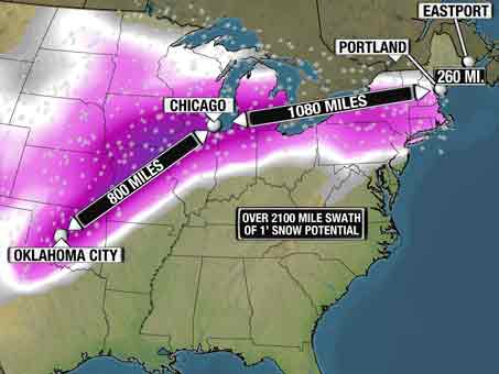
The wind today is straight out of the west, right around 10-15 mph.  This wind is steadily pushing that huge snow system around southern Wisconsin to the east.  Looking at a map on weather.com, there is a huge dip in the jet stream right around the northeastern part of the country, which is where the system that dumped two feet of snow on Chicago is currently located. 

I predict that tomorrow will be quite similar today, maybe a little colder, as there is still that cold wind blowing in our direction.

Tuesday, February 1, 2011

the weather today! my first blog! (1/31/2011)


The snow has been quite steady all day today. The temperature is also in the mid twenties which is why we are getting snowfall and accumulation. All of this nasty weather is just enough to make driving in /Wisconsin annoying and messy. With the warmer weather slush is everywhere...hopefully the temperature doesnt drop drastically or we may have some icy road problems!

The wind seems to be coming from a more northwestern direction, which leads me to believe that the snowfall we are getting is nothing compared to what areas to the south of wisconsin will be recieving. The snow will taper off into the afternoon and will probably stop before tomorrow.
Published with Blogger-droid v1.6.6

the weather today (2/1/2011)

The temperature today is a balmy 18 degrees with very little wind. I almost forgot what the sun was like for awhile...so I was very happy to see a cloudless sky today. Although as I am blogging the sky seems to be slightly overcast. The little wind that is present seems to be coming from the west...which is what I'm guessing is fueling the snow storm that is hitting the sounthern parts of Wisconsin.

Midwest storm

(photo from weather.com)

I'm predicting that we will have some snowfall this evening or in the early morning hours of tomorrow.
Published with Blogger-droid v1.6.6